USE CELLS THAT ARE 1000m x 1000m
K in layer 2 approximately = K2base * (1+ x (8/18000))
where x is the distance from the river, but this increase occurs in roughly a step-wise fashion every 2000 m due to the fact that layer 2 is 100% low K facies (we will call it the base K) beneath the river with gradually increasing K toward the hillside in approximately step wise fashion each 2000 meters.
e.g. >>>> K= 4x10⁻⁵ m2/s * 1 for first 2000m, 8x10⁻⁵ m2/s for next 2000 m, 36x10-5 m2/s for the 2000m section nearest the hillside
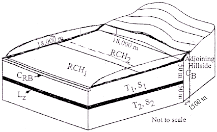
The basic parameter values for the system are as follows:
Recharge on the hillside is insignificant
| VARIABLE | VALUE | DESCRIPTION |
| K1 | 3 x 10⁻⁴ m/s | hydraulic conductivity of layer 1 |
| K2base | 4 x 10⁻⁵ m/s | hydraulic conductivity of layer 2 below the river |
| KnearHill | 3.6 x 10⁻⁴ m/s | hydraulic conductivity of layer 2 near the hillside |
| KVtards | 1 x 10⁻⁷ m/s | hydraulic conductivity of the aquitard |
| KRB | 1.2 x 10⁻³ m/s | vertical hydraulic conductivity of the river bed |
| KHILL | 2 x 10⁻⁹ m/s | hydraulic conductivity of the hillside material |
| RCH1 | 2 x 10⁻⁸ m/s | recharge near the river |
| RCH2 | 1 x 10⁻⁸ m/s | recharge near the hillside |
| S1 | 1.3 x10⁻³ | storage coefficient of layer 1 |
| S2 | 2 x10⁻⁴ | storage coefficient of layer 2 |
| b1 | 50 m | thickness of layer 1 |
| b2 | 50 m | thickness of layer 2 |
| bz | 10 m | thickness of confining layer |
| bRB | 10 m | thickness of riverbed |
| LHILL HEAD | 1500 m | distance to observation in hill |
| LCELL = LRB | 1000 m | length of cell parallel to river |
| WRB | 10 m | equivalent width of river |
| not applicable | 100 m | river stage |
| not applicable | 90 m | equivalent river bottom |
| not applicable | 350 m | hillside head |