and
Sean A. McKenna
Department of Geology and Geological Engineering
Colorado School of Mines
Golden, Colorado 80401
Current address: Sandia National Laboratories
Geohydrology Department, P.O. Box 5800, M.S. 1324, Albuquerque, New Mexico 87185-1324.)
email: smcken@nwer.sandia.gov
Reprinted from GROUND WATER, Vol. 33, No. 6, November-December 1995
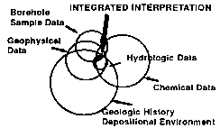
Usually we know more about a site than just the location of hydrofacies in boreholes, and this information can be used to rule out some, but not all, of the alternative interpretations. "Fusion" of these data (Olhoeft, 1992) reduces uncertainty associated with the interpretation. If each circle in Figure 2 represents the range of possible interpretations, then using all of the information together can significantly reduce the range of possible interpretations, thus reducing the uncertainty of the nature of ground-water flow and contaminant transport. In short, the sum of the parts is less than the whole! If the data circles do not overlap, the project team should strive to identify the shortcomings/errors in the data or determine what assumptions have been made that falsely constrain the interpretation.
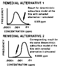
It is important to work with a range of subsurface interpretations because consideration of these alternative interpretations of the subsurface will yield a range of the response function (ground-water flow and advection-dispersion equation) values (head, flow rate, and concentration). For example, assume there is a contaminated site with two alternative remediation schemes. If there is only one deterministic picture of the subsurface, and the predicted concentration at the point and time of interest is 5 x 10⁻³ ppm for remedial alternative 1 and 5 x 10⁻⁴ ppm for remedial alternative 2, than alternative 2 appears to be the better choice. However, when the range of possible subsurface conditions is considered, it may be found that remedial alternative 2 actually has a higher probability of poor performance and the opposite selection would be made (Figure 3).
A current approach to this problem is geostatistical simulation using hard data, soft data, and spatial statistics to describe the character of the subsurface (McKenna and Poeter, 1994). Hard data are data with negligible uncertainty, such as direct measurements of hydraulic conductivity or observations of lithology. Soft data are information with non-negligible uncertainty, such as indirect measurements gathered in a geophysical survey and expert opinion regarding geologic fabric or structure. Hard and soft data are used to develop indicator semivariograms for the hydrofacies (represented by integer indicators) and to simulate numerous realizations [using multiple indicator conditional stochastic simulations, MICSS (Gomez-Hernandez and Srivastava, 1990)] of the hydrofacies configuration which honor the data and the statistical character of the subsurface. The hydrofacies within each realization are populated with hydraulic parameters and a forward flow and transport model is run to yield the distribution of predicted contaminant concentration over the model domain for a period of time. This process is extended through the use of inverse flow modeling which can be used to: (1) improve geologic interpretation, somewhat narrowing the distribution of predicted concentrations; and (2) eliminate realizations that do not fit the hydrologic data, significantly reducing uncertainty.
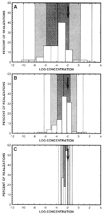
This study explores the uncertainty associated with predicted contaminant concentration calculated using three approaches and compares those uncertainties with the known concentration. Uncertainty of the geometric configuration and hydraulic conductivity of five hydrofacies are considered. The approaches include: (1) using hard geologic data from the domestic wells in MICSS to produce geologic realizations which are populated with hydraulic conductivities based on hydrofacies type and used in forward flow and transport modeling to predict the probability distribution of contaminant concentration at the proposed well location; (2) repetition of the first approach with addition of soft information regarding continuity of alluvial fan hydrofacies gained through inverse ground-water flow modeling; and (3) repetition of the second approach incorporating hydraulic data through application of inverse flow modeling. The MICSS code used is ISIM3D (Gomez-Hernandez and Srivastava, 1990) as modified by McKenna (1994).
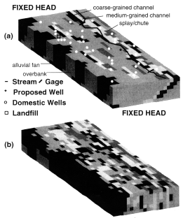
A synthetic "true stratigraphy" is constructed consisting of six layers of geologic materials designed to mimic a generic fluvial geology. Five hydrofacies are used in the synthetic data set: (1) medium-grained alluvial fan material, (2) fine-grained overbank deposits, (3) fine to medium-grained splay/chute deposits, (4) medium-grained channel deposits, and (5) coarse-grained channel deposits [Figure 4(a)]. All of the hydrofacies have a constant value of effective porosity and lognormally distributed (but not spatially correlated) hydraulic conductivities with a standard deviation of 1/6 in natural log space (thus K varies by a factor of three within any one facies and there is no significant overlap of K's between facies). These simplified hydrofacies properties are not representative of a field situation; however, a complex hypothetical distribution is not necessary to illustrate the process presented herein. The percentage that each hydrofacies represents in the synthetic system and their hydraulic properties are presented in Table 1.
| Facies | Volume Percent |
Mean K* (m/d) |
Effective porosity |
| Alluvial fan | |||
| Overbank | |||
| Splay/chute | |||
| Medium channel | |||
| Coarse channel |
* All K distributions have ![]() lnK = 1/6
lnK = 1/6
The alluvial fan hydrofacies are limited to the western edge of the alluvial valley, and are discontinuous. The main channel hydrofacies are oriented north-south and are further east in sequentially younger layers. Coarse-grained channel hydrofacies are discontinuous and occur on the outside bends of meanders. The medium-grained channel hydrofacies are more continuous. Fine to medium-grained channel hydrofacies are located along the main channels to represent splay deposits. Some medium-grained hydrofacies are located within the floodplain area to represent chute cutoff oxbow lakes. Fine to medium-grained hydrofacies of similar distribution represent neck cut-off oxbow lakes. This definition and spatial distribution of hydrofacies is a gross simplification of fluvial hydrofacies as presented by Allen (1965), Bridge and Leeder (1979), and Walker and Cant (1984).
A "true" steady state flow system is obtained with heads fixed at 100 m on the northern and 90 m on the southern boundary. An average recharge of 2 x 10⁻⁴ m/d is applied to the top of the domain with three times that rate applied at the margin of the valley (where overland flow from surrounding uplands infiltrates the system), and a zero rate near the stream which is a discharge area. The 31 domestic wells [Figure 4(a)] penetrate to various depths and pump at low rates (their discharges are normally distributed with a mean of 1 m3/d and a standard deviation of 1/6 m3/d). A head dependent flux boundary represents the stream [Figure (4a)]. The USGS code MODFLOWP (Hill, 1992) is utilized for the forward and inverse ground-water flow modeling. The forward simulation of the synthetic system using MODFLOW yields heads at 37 wells (31 domestic and 6 monitoring wells near the landfill) and ground-water discharge to the stream between gaging stations. Multilayer heads from MODFLOW were composited by averaging head of each layer weighted by transmissivity of the layer.
A "true" event of a breached landfill with recharge through the landfill at a dimensionless concentration Co = 1.0 is simulated for a conservative contaminant with constant dispersivities of 5 m, 1.5 m, and 0.25 m in the longitudinal, transverse horizontal and vertical directions, respectively for all hydrofacies. These dispersivities reflect advective variation at small scale within each hydrofacies, while larger scale dispersion is attained through the use of heterogeneity in the flow model. The simplification of similar small-scale dispersivity for each facies does not interfere with the illustration of the analysis process presented herein. The MT3D code is used with the MOC (Method of Characteristics) option and the fourth-order Runge-Kutta algorithm for particle tracking to simulate transport (Zheng, 1991). Time steps on the order of 10 days yield mass balances on the order of 1%. Forward transport modeling yields the "true" dimensionless concentration of 1.2 x 10⁻² (i.e. C/Co = 0.0012) at the proposed well location 50 years after the landfill began leaking. For the purpose of discussion we assume the regulatory level for this contaminant is C/Co = 1.0 x 10⁻³.
Variance of field observations must be defined for an inverse modeling procedure. The specified variance must reflect not only measurement error but also error related to the fact that the grid block represents average head over an area while the head measured in the well represents the head over the open interval at one location. Interpolation of head between grid blocks is used to determine the head that will be compared with the measurement; however, such interpolation does not consider the flow equations, thus a variance greater than that associated with measurement error must be specified for observations. In short, the selection of accuracy and confidence interval is somewhat arbitrary in both field and synthetic studies. How reasonably the user assesses this uncertainty is reflected by the code output. For this study, true head observations are specified with 90% confidence that the measured head is within 1.2 m of the head it represents in the model. The one flow observation (groundwater seepage into the stream between gage stations) is defined with 90% confidence that the measurement is within 400 m3/day of the true flows which are 10,500 and 15,300 m3/d at the up and downstream stations, respectively.
When inverse flow modeling (MODFLOWP) is used to estimate the hydraulic parameters of the system in each of these initial 100 realizations, the results do not produce the proper relative order of hydraulic conductivity for the hydrofacies. The relative order of hydraulic conductivity is determined from hydraulic testing of the hydrofacies in the field and observations of the material character: coarse-grained channel deposits have the highest hydraulic conductivity, followed by medium-grained channel deposits and alluvial fan deposits, fine-grained splay/chute deposits, and overbank deposits. Parameter estimations from this initial inverse modeling consistently indicate that the hydraulic conductivity of the alluvial fan hydrofacies is lower than that of the overbank hydrofacies.
It is concluded that the simulated alluvial fan hydrofacies are too well-connected in these initial 100 realizations. As a consequence, the inverse modeling procedure is estimating a low K for the alluvial fan hydrofacies in order to fit the "measured" heads which exhibit higher gradients produced by the "true" discontinuous zones of high K. Inspection of the realizations reveals the alluvial fan hydrofacies to be either completely continuous along the left boundary of the domain or connected to the high hydraulic conductivity hydrofacies of the continuous channel hydrofacies near the centerline of the domain in all of these first 100 realizations [Figure (4b)].
Given that hydrogeologists must make decisions based on incomplete information, it is necessary that these decisions incorporate a recognition of uncertainty. Stochastic modeling of geologic uncertainty provides a means of quantitatively addressing uncertainty in the response function (advection and dispersion). As shown in Figure 2, this paper presents incorporation of disparate types of information for reduction of uncertainty. This "data fusion" forces the resulting predictions of flow and transport to be consistent with all available data. Furthermore, this work demonstrates two techniques for incorporating disparate types of data into site assessment: use of soft data in stochastic simulation of geologic units and inverse flow modeling. In this case soft data are in the form of expert opinion on geologic conditions (which is identified through inconsistent results of inverse flow modeling). The same approach can be used to incorporate geophysical data (McKenna, 1994; McKenna and Poeter, 1994) and other types of expert knowledge about the site. Inverse modeling allows the incorporation of hydrologic data into uncertainty assessment through automated flow model calibration.
The first step in the demonstration of data fusion in this paper illustrates the danger of ignoring some of the available data. Using only hard data, to generate stochastic geostatistical simulation yields realizations of the subsurface which are implausible. These implausible realizations are most likely the result of biased sample data and violations of the underlying geostatistical assumptions of stationarity and ergodicity. Without the incorporation of hydrologic data into the modeling process, these implausibilities might not have been identified and the resulting response function would have remained imprecise. Analyses and data collection must focus on reducing uncertainty (increasing precision) while capturing the truth in the distribution of predicted concentration (maintaining accuracy).
Bridge, J. S. and M. R. Leeder. 1979. A simulation model of alluvial stratigraphy. Sedimentology. v. 26, pp. 617-644.
Gomez-Hernandez J. J. and R. M. Srivastava. 1990. ISIM-3D; An ANSI-C three dimensional multiple indicator conditional simulation program. Computers in Geoscience. v. 16, no. 4, pp. 395-414.
Hill, M. C., 1992. A computer program (MODFLOWP) for estimating parameters of a transient, three-dimensional, ground-water flow model using nonlinear regression. USGS OFR 91-484.
McKenna, S. A., 1994. Utilization of soft data for uncertainty reduction in groundwater flow and transport modeling. Colorado School of Mines PhD dissertation T-4291.
McKenna S. A. and E. P. Poeter, 1994, Simulating geological uncertainty with imprecise data for groundwater flow and advective transport modeling. In: Stochastic Modeling and Geostatistics: Case Histories and Practical Examples. J. Yarus and R. Chambers, eds. American Assoc. Petroleum Geologists Special Publication, Computer Applications in Geology, no. 3.
Olhoeft, G.R., 1992. Data fusion. Chapter 3 in Workshop on Non-invasive Geophysical Site Characterization. Compiled by E. Van Eeckhout and C. Calef. Los Alamos Report LA-12311-C UC-903. pp. 4-6.
Poeter, E.P., and D.R. Gaylord. 1990. Influence of aquifer heterogeneity on contaminant transport at the Hanford site. Ground Water. v. 28, no. 6, pp. 900-909.
Poeter, E.P., and S.A. McKenna. 1994. Geostatistical simulation and inverse flow modeling to reduce uncertainty associated with flow and transport predictions. Proceedings of the International Ground Water Modeling Center's 2nd conference, Fort Collins, CO.
Walker, R.G. and Douglas J. Cant. 1984. Sandy fluvial systems. In: Hydrofacies Models, 2nd ed., R.G. Walker, ed. Geoscience Canada. Reprint Series 1, pp. 71-90.
Wingle, W.L., S.A. McKenna and E.P. Poeter, 1995, UNCERT: A Geostatistical Uncertainty Analysis Package Applied to Groundwater Flow and Contaminant Transport Modeling, Colorado School of Mines.
Zheng, C. 1991, MT3D, a Modular Three-Dimensional Transport Model User's Manual. S. S. Papadopulos & Assoc., Rockville, MD